Anthony Bonanno
The focus of attention of this article is on a series of strange rock-cut features that mark some areas of the Maltese, predominantly Gozitan, rocky landscape.[1] Like the notorious Maltese cart-ruts, they are hewn on the surface of the bedrock and, for that reason, they do not present intrinsic stratigraphical indicators for their dating.
My first encounter with this facet of Maltese archaeology goes back to the very beginning of my university teaching career when, after an evening course lecture,[2] I was approached by a gentleman who showed me a photograph of a system of connected basins then visible on the rock surface somewhere at Wardija. He claimed that people referred to it as a magna tal-Ġobon (cheese-making machine). I never managed to see this particular feature in real life after that episode and I cannot tell whether it still exists.[3]
Some twenty years later my friend Dr Carol Jaccarini invited me over for a weekend in Gozo to show me a scattered group of such rock-cut systems in the area of Mġarr ix-Xini. We must have inspected about half-a-dozen of them, all scooped out of the surface of the bedrock close to the edge of either side of the canyon. Eventually, I was presented with a typescript of an article on these features, written by Dr Jaccarini and Prof. Maurice Cauchi, with a request to review it and give my views and suggestions. Eventually, the article was published in Melita Historica of 1999.[4] The publication was quite exhaustive, starting with a general topographical description of the area and providing a detailed description of each feature, accompanied by hand-drawn diagrams with measurements. The authors proposed tentative interpretations.
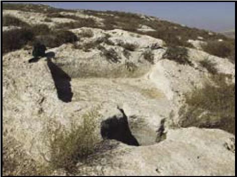
The basic concept of each feature is that of two rock-cut basins, one at a slightly higher level than the other, to which it is connected by means of a hole at its bottom. The upper basin is always square or rectangular in shape while the lower tends to be circular, smaller and deeper. They are often accompanied by much smaller bowl-like receptacles hewn in the rock on the side, connected with either the upper or, in one case, the lower basin. Occasionally, a series of deep cup-like depressions are distributed around the feature (Fig. 1).
What is strange is that these enigmatic basins somehow escaped the attention of antiquarian writers from Gian Francesco Abela (first half of the 17th century) to Antonio Annetto Caruana (second half of the 19th century). They even escaped the notice of Themistocles Zammit and other archaeologists and antiquarians of the 20th century. Their first mention was in 1946 when Cav. L. Zammit Haber submitted a list of the Mġarr ix-Xini basins to The Ancient Monuments Committee, a committee set up after the Second World War to draw up a list of historical, archaeological and architectural monuments for purposes of protection and conservation. So the article by Jaccarini and Cauchi was a timely and healthy evaluation of a hitherto ignored part of the Gozitan cultural heritage.
Distribution in Malta
As already inferred above, the major concentration of these strange rock-cut features is in an area to the south of Xewkija, on both sides of the Mġarr ix-Xini canyon. Jaccarini and Cauchi identified and published the best six representatives, but noted three more rudimentary ones.[5] One cannot fail to mention that the presence of at least two separate Roman villas in the area south of Xewkija can be inferred from the discovery of two stone basins of trapeta (olive crushers).[6] Whether there was ever a connection between the two categories of features, or not, needs to be established.
Another Gozitan example, this time at Dwejra, was mentioned in the same Melita Historica 1999 article, but was published in greater detail in another article in 2000.[7]
The fine specimen within the Misqa Tanks complex (between the Tal-Magħlaq catacombs and Mnajdra) is also illustrated in the 1999 article, but still awaits a proper study.[8] Its presence among the ‘prehistoric’ Misqa tanks does not imply contemporaneity with them, and it could have been inserted at a later stage. The Tal-Magħlaq catacombs, some 100 metres away, suggest the presence of an ancient (probably late Roman) rural settlement in the vicinity.
A similar combination of basins was observed by the present writer at the outer edge of a water reservoir connected with a qanat-type tunnel at Il-Qattara, in the picturesque valley of Dingli.[9] Although it presents the usual combination of a rectangular basin and a circular one, Keith Buhagiar expressed some doubts on whether it was intended to be of the same nature since part of it is actually built, that is, not rock-cut. Instead, he called my attention to a ‘possible rock-cut wine pressing device in a cave almost immediately below Il-Wardija ta’ San Ġorġ l/o Dingli’.[10]
It was only in July of 2008 that, by pure chance,[11] I came to know of two separate groups of similar rock-cut systems, one in the area of It-Tafal ta’ Binġemma (described in some detail in Appendix 1) and another one in the Ta’ Lippija area (described in Appendix 2).
The group of It-Tafal ta’ Binġemma consists of three such devices. One was carved on a huge detached boulder which seems to have rolled over on its side since then because the horizontal floor of the larger basin is now tilted on a steep angle.[12] The other two were cut out on the edge of the terraced rock contour at a slightly higher altitude. While one was carved on the upper surface of a projecting ledge and overlooks the fields below, the other was cut almost at the foot of a terrace so that part of it is now covered by the soil of the field below. Both systems have a feature that seems to be absent from the other Maltese specimens I have come across so far, but which occurs on many abroad, namely, a large, somewhat deep hole on the vertical rock wall behind the upper basin.[13]
A single set of rock-cut basins near the Laferla Cross was brought to my attention by Professor Joe Falzon (Fig. 2).[14]
Distribution abroad
The first time I have seen a similar feature documented for a country outside Malta was during a lecture on Corsican prehistoric archaeology given in 2001 at the National Museum of Archaeology in Valletta by Dr Joseph Cesari, head of the Antiquities Service of Corsica. At one stage, he showed a slide illustrating a similar combination of rectangular and circular basins. I personally saw and photographed two similar features carved on rocky outcrops in the woods on either side of Perperikon during an archaeological study tour of Bulgaria in April 2007. One was situated at the beginning, the other at the end of the last climb on this ancient, partly rock-cut, partly constructed sanctuary, 15 km northeast of the present-day town of Kardzhali in the Eastern Rhodopes, which goes back in time to prehistoric Thracian origins but remaining in use in historical times, when a Byzantine church was built on the upper terrace. In the tourist literature, the two rock-cut features are described as wine presses, connected with the cult of Dionysus, the Greek god of wine who originated in Thrace (Fig. 3).[15]
Another feature of the same type at Beit Ha’Emek, Israel, is illustrated in a recently-published book on ancient olive oil processing in Israel.[16] The author prefers to identify it as a ‘foot-treading crushing platform’ for olive oil pressing. Professor Anthony Frendo, however, informs me that such features are quite frequent in Israel and are generally identified as wine presses.[17]
On the other hand, on the hilly countryside of Ferruzzano, a small town facing the Ionian Sea in Calabria, Italy, as many as 700 similar features have been catalogued.[18] It is mainly these examples that provide the strongest evidence that such rock-cut features, including the M©arr ix-Xini ones, were almost certainly wine pressing devices.
Finally, a colleague from the University of Catania, Professor Pietro Militello, assures me that many similar palmenti are scattered in the Sicilian countryside.[19]

One of several combinations of basins hewn on the rock surface on either side of the valley leading down to Mġarr ix-Xini, Gozo.

Fig 2 – Laferla Cross rock cut basins
(courtesy: Prof. Joe Falzon)

Fig 3 – One of two rock-cut wine-presses each on either side of the mountain sanctuary of Perperikon, Bulgaria.
A rock-cut wine press at Eshelhashomron in Israel

General view of rock-cut wine press a) at It-Tafal ta’ Binġemma. The edge of the rock on which it was hewn has detached itself from the parent rock.
Interpretation
Following the suggestions proposed by Jaccarini and Cauchi, one could list at least four hypothetical purposes for which these rock-cut features were made: a) olive pressing to extract olive oil; b) grape pressing for wine production; c) retting of flax to produce linen; d) dyeing of fabrics with colours derived from plants or other mineral or animal sources; or any combination of these purposes. None of these single interpretations, however, satisfied completely the presence of all the components present in these features.
Before the introduction of electrically-powered, sophisticated machinery which compresses the whole process of olive oil extraction into a device of only 2-3 cubic metres, olive pressing in antiquity used to require an impressively large system of apparatus consisting of a long horizontal wooden beam fixed at one end and lowered at the other end by means of a capstan or a vertical screw anchored to the ground by a large rectangular block of stone, apart from a stone press bed to support the wicker basket containing the olive mash, and the stone vats for the decantation of the oil (Fig. 4).[20] Alternatively, the olive mash was pressed, always in a wicker container, on a free-standing press supported by a system of vertical and horizontal wooden beams fixed onto a large and heavy rectangular block of stone. In view of the above, olive pressing did not seem plausible on these modestly sized rock-cut devices.

fig 4. – Graphic reconstruction of a typical Roman olive pressing apparatus
(after J.-P. Adam, Roman Building Materials and Techniques, London-New York 2001).
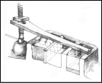
fig 5. – Graphic reconstruction of a typical rock-cut wine press (palmento) of the area around Ferruzzano in Calabria
(after Sculli 2002). Some of these wine presses were still functioning in the mid-20th century.
So far as the ancient past is concerned, although olive oil production is well documented in the Roman period (albeit only in terms of archaeological remains) by the surviving stone components of the apparatus mentioned above among the remains of Roman villas, wine production in the Maltese islands was never in the news. Again, although the same pressing apparatus found in the Roman villas could possibly be utilised also for wine pressing, the conspicuous presence of foreign wine amphorae in ancient archaeological levels suggests that in Punic, Roman and Byzantine times, wine production did not have much economic relevance for Malta, and most of the wine was imported.[21] This is the reason why wine pressing appeared at that time, prima facie, to be the less probable function of these basins, provided that their age went back that far.
In Malta, it is only in the beginning of the 20th century that wine started to be produced on industrial levels on the initiative of a handful of entrepreneurs. But one should not ignore the written evidence compiled by Godfrey Wettinger for a reasonably widely diffused viticulture in Late Medieval Malta.[22] At one stage, precisely in 1434, we find that ‘the town authorities of Malta complained that the importation of foreign wine was harming Maltese viticulture which provided a livelihood for a thousand inhabitants, a figure acceptable only if it included the labourers together with their dependents’.[23] A Medieval use for these rock-cut devices for wine production, therefore, remained a possible interpretation.
On the other hand, a close inspection of the immediate environment and the minor elements surrounding the basins suggested that the most plausible interpretation was that of the processing (retting and/or dyeing) of linen.
The basins were located close to water sources or water courses.[24] Linen is mentioned by Diodorus Siculus (writing in c. 60-30 BC) as the fabric of the Maltese textiles which enjoyed a respectable reputation in antiquity for their sheer quality.[25] Flax retting is mentioned in Late Medieval documents and referred to in old place-names, one of which, Għadira tal-Wied ta’ Mġarr ix-Xini, coincided with the locality of the major concentration of such features documented so far.[26] Besides, dyeing seemed at that point in time to best explain the purpose of the small rock-cut containers connected with one or the other of the larger basins, namely, for the controlled addition of colouring.
This was the situation till 2007. In that year, a series of developments suggested a re-examination of the evidence for the purpose of these features.
The first eye-opener came by way of a copy of a book kindly donated to me by Dott. Santino Pascuzzi early in that year.[27] The book, authored by Orlando Sculli, is a very scholarly study of very similar rock-cut basin systems scattered all over the hilly countryside of Ferruzzano, a small paese in the Locri province of Calabria.[28] Apart from a detailed illustrated catalogue of the most representative examples, the book describes the various components of these systems and illustrates graphically how they work (Fig. 5). The author proves beyond any shadow of doubt that they were palmenti (i.e. wine presses) because some of them were still in use for that purpose up to the 1950s. In his detailed discussion of their dating, he makes some examples date to the ancient Greek age,[29] and the majority to the Roman period. Some were undoubtedly still in use in the Byzantine age when typical Byzantine crosses were engraved on them. As the Gozitan examples were very similar to the Ferruzzano ones, their interpretation as wine-presses suddenly appeared the most probable one.
In Easter 2007, this was followed by an archaeological tour of Bulgaria where two rock-cut features like the Ferruzzano ones were encountered and photographed on either side of Perperikon, an impressive sanctuary, partly rock-carved and partly built on the sides and top of a steep rocky hill in the hodope mountains (Fig. 3). According to the local tradition, the sanctuary had its origins in Thracian prehistory and the two features were none other than wine-presses connected with the Greek god of wine drinking and revelling, Dionysus, who was supposed to have hailed from Thrace. The type of rock in which the presses were carved was a very friable sandstone, similar to the Ferruzzano one, and the features manifested an advanced state of erosion. The idea of wine pressing, therefore, was affirming itself on firmer ground.
So far, however, I had no interest in, or intention of involving myself directly in the discussion around these features until, that is, I received an invitation from the same Dott. Pascuzzi to give a paper on the Maltese ‘pans’ in a convegno due to be held at Ferruzzano in August 2007. The first of a three days’ stay in Brancaleone, after an early-morning flight to Reggio, was spent in the company of Santino Pascuzzi, Nathaniel Cutajar and the author Orlando Sculli on an intensive survey of some of the palmenti around Ferruzzano. Many of them were difficult to reach and involved climbing high walls and jumping back from same. One example was completely invisible, surrounded by thick undergrowth, and it was only the expert topographical knowledge of our guide that made access to it possible.
The close similarity to the Maltese basins was confirmed; if anything, the Calabrian ones were consistently deeper. The climax for me was when we were shown a particular palmento, still covered by a constructed rural room, which, although clearly abandoned for decades, preserved all the stone and wooden apparatus used for wine-pressing until the 1950s. This direct experience convinced me even further that the likeliest purpose for the Maltese pans was the same as that of the Ferruzzano palmenti, that is, wine pressing. But there were still nagging dissimilarities in the Maltese, mainly Gozitan, examples that required explanation, such as the presence of additional secondary holes and cup-like depressions around the basins.
The final and definitive confirmation came while I was word-processing this article, that is, in August 2008, when Mr Charles Spiteri and Mr Vincent Vella of Mġarr showed me a group of three such pan systems in a field belonging to Mr Vella on the sides of It-Tafal ta’ Binġemma, overlooking Mġarr. Two of these, described in some detail in Appendix 1 infra, had the corroborating evidence I was waiting for: the hole on the vertical rock surface behind the upper basin which was clearly intended for the insertion of the horizontal beam which, in turn, was pulled down with weights from the opposite end to exert pressure on the grapes in the upper basin. The juice from the pressed grapes must have flowed down by gravity into the lower basin via a hole at the bottom of the upper basin connecting it to the lower one. The juice was then collected from the lower basin and transported to wherever it was processed into wine. The detailed reconstruction of the Calabrian palmenti by Sculli (reproduced here in Fig. 5), therefore, can be taken on board to explain the mechanism of the Maltese ones. Since all the other wooden, metallic and stone paraphernalia involved in this mechanism have gone completely lost in the Maltese specimens, together with any written, as well as oral, documentation of traditional Maltese wine-pressing, we depend on these reconstructions of the much better preserved ones of Ferruzzano.[30] The small holes around the devices still remain a bit of an enigma: the likeliest function one can suggest is that of the insertion of some wooden frame to facilitate the pressing mechanism.
The dating of the Maltese rock-cut wine-presses solely on internal evidence remains problematic. Like the Maltese cart-ruts they are carved on rock and therefore the traditional archaeological methods of excavation are unlikely to be helpful, unless one finds one of them sealed by a datable uncontaminated stratigraphic deposit. Even then, it would be that particular specimen which was dated by the established terminus ante quem (date before which). Other specimens could have been hewn and used later in time. As in the case of the cart-ruts, help comes from similar phenomena abroad.
Literary evidence for the use of such devices in open countryside, right next to, or in the midst of vineyards comes from the Scriptures, both Old and New Testaments, which goes to prove that the custom of using such simple wine presses goes back to Biblical times. The first is a passage from Isaiah (5, 1-2): ‘My beloved had a vineyard on a very fertile hill. He dug it and cleared it of stones, and planted it with choice vines; he built a watchtower in the midst of it, and hewed out a wine press in it’.[31] This vignette is echoed in the gospel of Matthew (21, 33): ‘Hear another parable. There was another householder who planted a vineyard, and set a hedge around it and dug a wine press in it, and built a tower, and let it out to tenants, and went into another country’. Given the nature of a wine press of this type, requiring a hard, solid matrix, there is no sense in digging it in loose soil. It had to be hewn in solid rock, like the ones in question. Examples of such wine presses, I am told, are quite common in the rural landscape of Palestine (Fig. 6)[32]
For the full extent of their existence, however, the most helpful indications come from their Calabrian counterparts, some of which go back to Roman, possibly even Greek, times. Orlando Sculli has compiled a whole body of archival evidence for viticulture in the area during the Byzantine period when some palmenti seem to have been adorned with incised or relief crosses.
A substantial number of them, then, are known to have been still in use till the mid-20th century.
The Maltese ones seem to have gone out of use much earlier, but it is not possible to say when. The problem is that no verbal tradition has survived regarding them, neither written, nor oral. As we have seen, there were stages in the Late Middle Ages when wine did seem to play an important economic role, and some of these wine-presses could belong to those times. It is likely that, at least, some of them go back to the Roman period, but we await the official publication of the results of the research project at Mġarr ix-Xini to confirm such a dating.
Appendix 1
The wine presses at It-Tafal ta’ Binġemma

Rock-cut wine press a) at It-Tafal ta’ Binġemma. A combination of three communicating holes at the upper side of the larger basin.

Rock-cut wine press b) at It-Tafal ta’ Binġemma. The side of the lower basin connected with the upper basin by a hole.

Rock-cut wine press b) at It-Tafal ta’ Binġemma. Deep hole on the vertical wall at the back end of the higher basin.

Rock-cut wine press c) at It-Tafal ta’ Binġemma. General view

Rock-cut wine press c) at It-Tafal ta’ Binġemma. Deep hole on the vertical wall at the back end of the higher basin

Rock-cut wine press c) at It-Tafal ta’ Binġemma. Several minor holes flanking the lower basin.
Three rock-cut wine presses were examined in this area to the south of Mġarr. All three of them are scooped out of the horizontal surface on the edges of the natural rock terraces that characterize this steep hillside of Binġemma, on the contour falling roughly between 10 and 20 metres below the Victoria Lines of Dwejra (that is, c. 170m. a.s.l.) (Grid Ref.: 439 740). As the placename implies, the soil in this area is very clayey and the hillside has been turned into slightly inclined terrace fields by utilizing, as retaining walls, the alignments of huge boulders that have detached themselves from the higher coralline layer over the last thousands of years and deposited themselves at different levels on the same hillside. To reach them, from Mġarr one has to take the road to Il-Wilġa ta’ Binġemma, turning left (east) at the level of the Pumping Station. The property in question, known also as Tal-Liru, is reached beyond the end of a steep, concrete-surfaced, uphill road; it extends over three terraces as described above.[33]
a) The first set of basins is met as soon as one turns left (east) from the concrete road to the lowest terrace of the field. It is carved on the horizontal surface of a huge coralline boulder that has somehow detached itself from the parent rock and tilted sideways, because the floor surface of both basins is now at a steep angle (c. 20o) to the horizontal. This shift must, therefore, have taken place after the carving of the basins (Fig. 7). The higher level basin is rectangular in shape and measures 1.00 x 1.48m with a depth of about 15cm. All the edges, however, except for the western end, have been worn down to almost the floor level. This means that only a faint trace has survived of the hole that connected it with the lower basin (Fig. 8). The smaller basin at the lower level is roughly oval in shape and measures 0.77 x 0.40m. It is also 15cm deep. Beyond the smaller basin is a sharp drop onto the lower field. A combination of three communicating holes at the opposite side of the larger basin might have served to attach the head of the horizontal pressing beam (Fig. 9).
b) The second set is on a slightly higher level and some 20 metres to the east. This time the basins have been cut at the very lower end of the terraced rock, so that the lower basin is now covered by soil. Only the outline of the upper edge of the side closest to the higher basin is visible. It seems to have had a semicircular shape with the straight side (c. 1m. wide) connected with the upper basin via a perforation in the rock (Fig. 10). Two rock-cut ‘rope-holes’, one on either side, might have served to attach ropes to pull down the horizontal wooden beam which had its head inserted in a deep hole on the vertical wall at the opposite end of the higher basin (Fig. 11). The upper basin is roughly square and measures 0.95 x 0.95m. Originally, it must have been more than 15cm deep all round, but the north side, closest to the lower basin, has been worn down almost to floor level. Another, but shallower and roughly circular basin has been cut on the east side of the square basin. It is connected via a channel to the small circular hole (the rope hole mentioned above) which has another perforation apparently leading into the lower basin.
c) The third set is cut on the upper edge of the rock terrace with a sharp drop beyond it into the lower field, but the orientation of the sequence of basins is sideways (Fig. 12). Even in this case the upper basin has a hole on the vertical wall at its back, probably for the insertion of the head of the horizontal pressing beam (Fig. 13). The basin is almost rectangular, 1.25m long and between 1m and 1.15m wide. The depth also varies from 15 to 25 cm. The lower basin is almost oval, measuring 0.75 x 0.80m and c. 25cm deep. As usual, a small hole at the bottom of the upper basin connects it with the lower one. Two shallow hollows, this time one on either side of the lower basin, seem to have been intended to secure some wooden frame. A third circular hollow at a lower lever might have served the same purpose (Fig. 14).
Note
The presence of hollows in the vertical rock surface at the back of the upper basin in the last two examples in all probability served for the insertion of a horizontal beam used to exert pressure on the contents of the upper basin. I firmly believe that this constitutes additional evidence that these rock-cut features were intended for pressing some agricultural product, such as grapes, rather than for retting, as suggested before.
Appendix 2
The wine presses at Il-Lippija

Rock-cut wine press a) at Il-Lippija. General view.

Rock-cut wine press b) at Il-Lippija: the oval-shaped lower basin. Only the straight edge of the upper basin is visible on the right
The site in question is reached from the road that leaves Mġarr in the direction of Ġnejna, taking the right turning to Il-Lippija and Għajn Tuffieħa just before starting the descent towards the bay. At the end of the made-up road is a series of garigue (xagħri) plots of land bounded by low and flimsy rubble walls.[34]
At the opposite end, the property overlooks the valley of the Roman Baths of Għajn Tuffieħa, so that the site is accessible also from that side.[35]
a) The first set is very easy to identify if you know where to find it, like our guide did. He also knew that what is visible is only part of a larger system, part of which is covered by a small reclaimed field above it. In fact, traces of rock-cut basins are visible beyond the rubble wall on the opposite side of the small field. The visible part, however, forms a complete wine-press combination. Again, it is carved on the upper edge of a bedrock terrace (as opposed to the rock boulders of Binġemma). The sequence of basins is also oriented sideways, along the edge of the rock terrace (Fig. 15). It consists of an upper, almost square, basin measuring 1.16 x 1.10-1.17m. It is comparatively deep, 30 cm. It is connected by means of a large square hole (14 x 13 cm) to a lower basin, much smaller in size but deeper (44 cm) and of irregular shape. A very unusual element is the rock-carved, but partly broken, spout that projects from the upper into the lower basin (Fig. 16). Another higher basin was originally carved on the opposite side but only traces of it survive. It was also connected to the lower basin by means of a smaller hole, at the outer corner. Even this set has a number of hollows, one of them as much as 30cm deep, on either side of the larger basin, possibly for securing some wooden frame.
b) About 100 metres further east is another set on a spot which overlooks the main road to Għajn Tuffieħa. This time, only the lower basin is visible (Fig. 17). It is oval in shape and was formerly connected by a hole to the upper basin that has been concealed by a heap of stone chippings; only its edge just beyond the connecting hole is visible. It seems that, at some stage, another basin with a similar oval shape was carved in the opposite direction giving the whole the shape of a pince-nez. The floor of this second basin too is on a higher level. The floor of the lower basin ranges from 27 to 37 cm in depth. This time one small hollow is visible, at the corner where the lower basin met the covered upper basin. What is striking in the case of these two wine presses is the absence of cultivated fields within a radius of 200 metres. The area is in fact predominantly garigue and starts to turn into proper cultivated fields beyond the lip of the plateau, where the terrain descends into the valley of Għajn Tuffieħa. Consequently, vines could have been grown only in small pockets of soil amid the rocky terrain, or else some distance away.
_______________
NOTES
[1] This article is based on a public lecture given at Heritage Malta in January 2008, later given to Wirt Għawdex in Gozo. Since then, it has been possible for me to amplify it with the addition of more, previously unrecorded, features of the same kind in two other areas in Malta.
[2] It must have been around 1975, at a time when Archaeology lectures were given only in the evening since Archaeology was not introduced as a normal study area for the Bachelor’s degree before 1987.
[3] The photograph had no scale and I could not tell whether the dimensions of the basins fitted those of the features under examination.
[4] C. J. Jaccarini, and M. N. Cauchi, ‘The Enigmatic Rock-cut Pans of M©arr ix-Xini’, Melita Historica, xii, 4, 1999, 419-444.
[5] The Superintendence of Cultural Heritage has been conducting a thorough survey of the Mġarr ix-Xini valley over the past three years. See V. Macdonald, ‘Malta exports wine … in antiquity’, on http://www.di-ve.com on 23.vii.2008. The interviewee stated that Pantelleria pottery dating to Late Antiquity was found in the area during the project.
[6] An ‘ancient mill-stone from lands “tal-Ħamrija”, Xewkija’ in Museum Annual Report 1906, 3. Another one, now in the Gozo Archaeological Museum is from a ‘field wall a half mile south’ of Xewkija: Museum Annual Report 1958-9, 4.
[7] C. J. Jaccarini, and M. N. Cauchi, ‘The Mysterious Pans of Gozo’, The Gozo Observer, 3, February 2000, 7-9. A colour photograph was kindly provided by Prof. George Camilleri.
[8] A measured drawing to scale was kindly made available by Dr Nicholas Vella.
[9] These are horizontal tunnels penetrating the sides of valleys at right angles in order to allow the water accumulated in the perched water table to flow out for use in the irrigation of terraced fields. They seem to follow ancient prototypes (called ‘qanat’) in ancient Persia, from where they seem to have spread to the arid and semi-arid parts of the Roman Mediterranean. Keith Buhagiar has been conducting an extensive study of these agricultural devices: K. Buhagiar, ‘Water management strategies and the cave dwelling phenomenon in Late-Medieval Malta’, Medieval Archaeology 51, 2007, 103-131.
[10] Keith Buhagiar: personal communication 14.i.2008.
[11] As a result of a brief encounter with Charles Muscat of Mġarr, Malta, on 22 July 2008. I am very grateful to Mr Muscat for indicating the existence of these features and for introducing me to Ċensu Vella and Duminku Schembri who accompanied us to the sites in question.
[12] Unless, that is, it was originally the edge of a natural, projecting rock terrace which has broken loose of the parent bedrock at some time after the creation of the man-made feature. The whole area is indeed characterised by the presence of such rock boulders all along the different contours of the side of the hill below the Victoria Lines at Dwejra. This phenomenon may provide some indication of the antiquity of these rock-cut features. Another indicator of their age is the high degree of erosion of the surface of these features, reducing considerably the depth of the basins.
[13] For the purpose of these holes refer to the Appendices infra.
[14] Prof. Falzon also kindly provided this photo of the feature on 5 February 2008.
[15] Illustrated in images nos 015, 016 and 019 on http://www.imagesfrombulgaria.com, accessed on 27.vii.2008.
[16] P. Warnock, Identification of Ancient Olive Oil Processing Methods based on Olive Remains, Oxford 2007, 29-31, fig. 13.19.
[17] A. Frendo, personal communication November 2008. See infra pp. 13-14 and notes 31-32
[18] See infra p. 9 and note 28.
[19] During a study tour of southeastern Sicily, conducted in November 2007 as part of the K.A.S.A. European project, one such feature was encountered in the vicinity of Castelluccio.
[20] The olive mash was produced separately by the olive pipper (trapetum) or olive crusher (mola oleatoria). For a vivid and comprehensive reconstruction, see A. Bonanno, Malta, Phoenician, Punic and Roman, Malta 2005, 180.
[21] B. Bruno, L’Arcipelago Maltese in Età Romana e Bizantina: attività economiche e scambi al centro del Mediterraneo, Bari 2004, 139-157.
[22] G. Wettinger, ‘Agriculture in Malta in the Late Middle Ages’, in Proceedings of History Week 1981, ed. M. Buhagiar, Malta 1982, 23-27.
[23] Ibid., 23.
[24] The ones at Mġarr ix-Xini, as we have already noted, are on the very edges of that river valley. Even the newly recorded devices at It-Tafal ta’ Binġemma are situated close to the outlet of an underground water gallery; and those at Ta’ Lippija are not too far from the water spring that in antiquity fed the Roman Baths at Għajn Tuffieħa (see infra).
[25] Although Cicero (writing in 71-70 BC), among various ancient writers, is the one who mentions the Maltese fabrics most often, at one stage implying a febrile weaving activity in the ancient city of Melite (Verr. II, 2, 176, 183; 4, 103), it is Diodorus Siculus (V, 12, 1-4) who specifies that the fabric was linen (othonia).
[26] Wettinger, 1982, 29-31; Id., Place-Names of the Maltese Islands ca. 1300-1800 Malta 2000, 177-179 (Għadir-Għadira), 343 (Kittien-Kittenija).
[27] Dott. Pascuzzi represents the Istituto per l’Arte e il Restauro Palazzo Spinelli Florence on the Board of Studies of the MA course in Cultural Heritage Management of which I am chairman.
[28] O. Sculli, I Palmenti di Ferruzzano, archeologia del vino e testimonianze di cultura materiale in un territorio della Calabria meridionale, Florence 2002.
[29] Most of the Calabrian coast was colonised by the Greeks as from the 7th century BC, Rhegion and Lokri, on either side of Ferruzzano, being two main such colonies.
[30] Even though I would not exclude, indeed I would look forward to, new documentation being discovered. For this reason I would encourage anybody who has knowledge of more specimens of such devices to report them to the Superintendence of Cultural Heritage who are in the process of surveying the Mġarr ix-Xini ones, where they have already identified as many as 15 of them (see Macdonald, note 5 supra).
[31] I thank Prof. Anthony Frendo for confirming that the word for the dug feature in the original Biblical text could mean also ‘wine press’ and not just ‘wine vat’ as reproduced in the Revised Standard Version. The Maltese version gives it as ‘mag˙sar’.
[32] Anthony Frendo, personal communication. I also thank him for the web source of this illustration.
[33] I would like to thank Mr Charles Spiteri of Mġarr for the interest he took in the subject and for leading me on to Mr Vincent Vella, the owner of the land in question, who kindly showed me these and other features of interest in the area.
[34] Strictly speaking, the area under consideration is covered by the name of Ix-Xag˙ra ta’ G˙ar is-Sienja in the Survey Sheets (Grid Ref. 418 719).
[35] The property appears to serve a rustic and primitively built troglodytic farm at the upper end of the hill. The whole complex has recently been surrounded by a better-built rubble wall. I would like to thank Mr Dominic Schembri of Mġarr for kindly showing me the archaeological features in this area.

One thought on “Maltese Wine Pressing in Antiquity”