The Maltese word for a lighthouse is fanal.
Lighthouses in Malta are maintained and operated by Transport Malta, which has absorbed the former Malta Maritime Authority.
Gozo Lighthouses
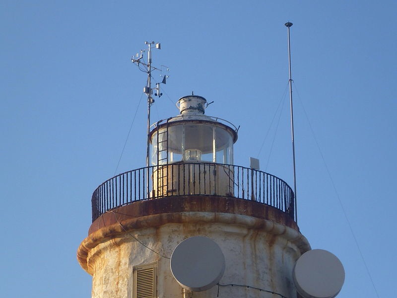
Ġurdan
Also known as: Gordan Light or Gurdan Light
Nearest Town or City: Ghammar – Ghasri
Location: Gurdan Hill, northwest tip of Gozo, Mediterranean Sea.
Managing Organization: Malta Maritime Authority
This lighthouse serves as the principal Global Atmospheric Watch Station for the Central Mediterranean.
Tower Height: 66
Height of Focal Plane: 592
ARLHS MLT-003; Admiralty E2050; NGA 10504.
Characteristic and Range: Flashing white every 7.5 seconds, visible for 20 nautical miles.
Description of Tower: White tower on dwelling.
This light is operational
Date Established: c. 1650s
Date Present Tower Built: 1853
Date Automated: 1994
Current Use: Active aid to navigation, Global Atmospheric Watch Station.
Focal plane 180 m (591 ft); white flash every 7.5 s. 22 m (72 ft) round stone tower with lantern and gallery, rising from a 2-story stone keeper’s house. Tower and lantern painted white; the house is unpainted. This lighthouse is the landfall light for ships arriving in Malta from the west.


Mġarr North Breakwater
Date 1970s.
Focal plane about 7 m (23 ft); green flash every 5 s. 5 m (17 ft) round strongly conical concrete tower mounted on a round base.
Lighthouse painted with green and white horizontal bands. Located at the end of the north breakwater of Mġarr, the port at the west end of Għawdex. Site and tower closed, but there’s a good view from ferries arriving from Malta.
Admiralty E2051.2;
NGA 10512.

Mġarr Main Breakwater
Date 1970s.
Focal plane about 8 m (26 ft); red flash every 4 s. 5 m (17 ft) round strongly conical concrete tower mounted on a round base. Lighthouse painted with red and white horizontal bands. Located at the end of the south (main) breakwater of Mġarr, the port at the west end of Għawdex. Site and tower closed, but there’s a good view from ferries arriving from Malta.
Admiralty E2051;
NGA 10508.

Malta Lighthouses
Portomaso Marina
Name: Portomaso Marina Light
Nearest Town or City: St Julian’s
Location: Grand Harbour entrance, west side of St. Julians Bay.
Managing Organization: Portomaso Marina
Description of Tower: Marina control room on piles.
This light is operational
Current Use: Private aid to navigation.
Date: 1990s.
Focal plane about 8 m (26 ft); flashing red light. 6 m (20 ft) locomotive-style lamp atop the domed roof of a small octagonal 1-story marina control room, mounted on 8 concrete piles. This light marks the entrance to the marina of an upscale resort development. Located on the Ponta ta’ Spinola, on the north side of the island of Malta and the west side of St. Julian’s Bay about 2.5 km (1.5 mi) northwest of Sliema. Site open, tower closed.

Valletta (Fort St. Elmo)
Station established 1851.
Focal plane 49 m (161 ft); three white flashes every 15 s. Approx. 10 m (33 ft) square steel skeletal tower with gallery, mounted at the highest point of a large stone fortress. Dominating the harbour of Valletta, Fort St. Elmo dates from the 16th century. Most of the fort is now a museum, and the rest is being restored after housing the Royal Malta Artillery and then the police Accademy. Located at the tip of the peninsula separating the Grand Harbour from the Marsamxett Harbour in Valletta. ARLHS MLT-007;
Admiralty E2061.5;
NGA 10544.


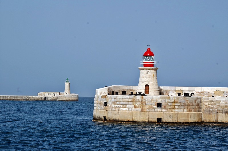
Valletta St. Elmo (Grand Harbour West Breakwater)
Also known as: St. Elmo Breakwater Head Light
Also known as: Gran Fanale Light
Nearest Town or City: Valletta
Location: West side of entrance to Grand Harbor.
Managing Organization: Malta Maritime Authority
Tower Height: 23
Height of Focal Plane: 52
ARLHS MLT-002;
Admiralty E2062;
NGA 10548.
Characteristic and Range: Quick flashing green, range 7 nautical miles.
Description of Tower: White cylindrical tower, red band on east side.
This light is operational
Date Established: c. 1450
Date Present Tower Built: 1908
Current Use: Active aid to navigation.
Focal plane 16 m (52 ft); quick-flashing green light. 14 m (46 ft) tapered stone tower with lantern and gallery. Tower unpainted, lantern painted green. The two breakwater lighthouses stood without their lanterns for decades, but in 2012 replicas of the original lanterns were installed. Located at the end of the breakwater on the west side of the entrance to the Grand Harbour of Valletta.There are good views from ferries arriving in Valletta. Site and tower closed.


Ricasoli (Grand Harbour East Breakwater)
Also known as: Ricasoli Breakwater Light
Nearest Town or City: Kalkara
Location: East side of entrance to Grand Harbour, opposite the St. Elmo Light.
Managing Organization: Malta Maritime Authority
Tower Height: 30
Height of Focal Plane: 36
ARLHS MLT-004;
Admiralty E2064;
NGA 10552.
Characteristic and Range: Quick red flash, visible for 6 nautical miles.
Description of Tower: Metal structure on white conical tower with red bands on the east side.
This light is operational
Date Established: 1908
Date Present Tower Built: 1908
Current Use: Active aid to navigation.
Focal plane 11 m (36 ft); quick-flashing red light. 9 m (30 ft) tapered stone tower with lantern and gallery. Tower unpainted, lantern painted green. Located at the end of the breakwater on the east side of the entrance to the Grand Harbour of Valletta, adjacent to Fort Ricasoli. Accessible by walking the pier, and there are good views from ferries arriving in Valletta. Site open, tower closed.


Delimara Point (old)
Name: Delimara Point Light (old)
Nearest Town or City: Marsaxlokk
Location: Southeastern point of Malta, Mediterranean Sea.
Managing Organization: National Trust of Malta (Din l-Art Helwa)
This lighthouse has been replaced by an automated light nearby. The National Trust of Malta has completed its restoration in February 2014.
Height of Focal Plane: 150
ARLHS MLT-001.
Description of Tower: Octagonal tower with black and white horizontal bands, on top of building.
This light is functional but not operational
Date Established: 1855
Date Present Tower Built: 1855
Date Deactivated: c. 1990
Current Use: Historic site.
Inactive since about 1990.
Approx. 22 m (72 ft) octagonal stone tower with lantern and gallery, rising from a two-story stone keeper’s house. Lighthouse painted black with a white horizontal band. The house is unpainted.
Located at the southeastern tip of Malta, about 3 km (2 miles) southeast of Marsaxlokk. Site manager: Din l-Art Ħelwa.
This 19th century landmark was constructed by the British Authorities shortly after the building of the Ta’ Giordan lighthouse in Gozo. Until 1896, the Lighthouse boasted a static red lantern but this was then replaced by a more powerful gasoline lamp, operated by hand-wound mechanism, that produced beams of alternating red and white light flashed at intervals of 30 seconds. Its arc of visibility ranged from bearing of 19 to 295 degrees up to a range of 19 nautical miles. The Delimara Point Light served as the landfall light for ships arriving in Malta from the east. The lighthouse also marks the north side of the entrance to the harbour of Marsaxlokk.
The lighthouse deteriorated badly after being deactivated in 1990. In March 2006, the Malta Maritime Authority entrusted the inactive lighthouse to Din l-Art Ħelwa. The restoration of the Delimara Lighthouse, a project undertaken by Din l-Art Helwa and supported by GasanMamo Insurance and planned in three phases, with the final aim that of offering visitor accomodation in a historic site, came to an end in February 2014. During the First phase, stareted in 2007, the Trust completed a restoration of the building on the outside. The second phase involved internal works such as plumbing and electricity, maintenance of internal apertures and the installation of a kitchen and bathrooms. The first two phases were completed by the first months of 2008.
The lantern and lens were restored in a third phase of the project, which was underway between late 2010 and February 2014. The third and last phase which took five years in all, included the restoration of the light mechanism and its housing, gas prisms and lantern mechanism. Restoration of iron works, hydraulics and mechanism was entrusted to Anthony Spiteri of JMS Metal Works of Ta’ Qali. The glass panes of the lighthouse had to be removed one by one very carefully to haul the mechanism, while the stone structure had to be cleaned on site. The cast iron was painstakingly cleaned and given a protective layer to prevent corrosion. Work on the mechanism which used to light the structure was undertaken and some missing lenses were replaced. There was difficulty replacing the red glass prisms that formed part of the beacon’s signal, as these were no longer being produced.


Delimara Point (new)
Name: Delimara Point Light (new)
Nearest Town or City: Marsaxlokk
Location: Southeastern point of Malta, Mediterranean Sea.
Managing Organization:Malta Maritime Authority
Height of Focal Plane: 115
Admiralty E2070;
NGA 10564
Characteristic and Range: Two white flashes every 12 seconds; range 18 nautical miles.
Description of Tower: Light on a two-story building.
This light is operational
Date Present Tower Built: c. 1990
Current Use: Active aid to navigation.
Focal plane 35 m (115 ft); two white flashes every 12 s. 2-story masonry building topped by communications gear. Located a short distance north of the historic lighthouse. Site open, tower closed. .

Tigne’ Point
Name: Marsa Muscett Light (This lighthouse no longer exists)
Nearest Town or City: Sliema
Location: Tigné Point, on the north side of the harbour.
There were two lights on the tower, arranged vertically.
Description of Tower: 1859: Circular tower on white pillars; focal plane at 71 feet. 1904: White, square stone tower; focal plane at 80 feet.
This light is not operational
Date Established: 1859
Date Deactivated: 1900s

Fort Ricasoli Light
Nearest Town or City: Kalkara
Location: South side of the entrance to Valletta Harbour.
There were two lights on the tower, arranged vertically. The focal plane of the higher light was 79 feet.
Description of Tower: White tower on the northwest corner of the fort.
This light is not operational
Date Established: 1858
Date Deactivated: 1900s


Very interesting information.Keep it up.